

REST API, Service version 1.0.0
EV smart routing · v1.0#
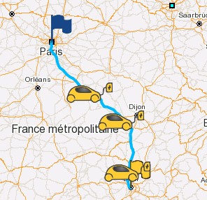
Performs a route calculation dedicated to electric vehicles. If the vehicle's range is insufficient to reach the final destination, this service returns a route that includes deviations to charging stations (also known as step points).
Request#
The request must be sent using the HTTP POST method with the Content-Type header set to application/json.
Sample:
End-point URI: /bgis/service/evsmartrouting/1.0.
HTTP header: Content-Type: application/json.
POST data:
{
  "vehicle": "06b5c02d-ba2e-4b14-8b2b-6d793aac0da0",
  "initBatLvl": 100,
  "minBatLvl": 10,
  "minArrivalBatLvl": 15,
  "temperature": 20,
  "payload": 75,
  "startLon": 2.3414,
  "startLat": 48.85717,
  "stopLon": 4.82965,
  "stopLat": 45.75917,
  "pl": false,
  "epl": true,
  "cur": "EUR"
}
All coordinates are defined by longitude and latitude, see the coordinate system glossary for more details.
Parameters#
startLonnumber (double)requiredDeparture longitude in decimal degrees (WGS84). Ensure these values are provided in decimal degrees format.
startLatnumber (double)requiredDeparture latitude in decimal degrees (WGS84). Ensure these values are provided in decimal degrees format.
stopLonnumber (double)requiredArrival longitude in decimal degrees (WGS84). Ensure these values are provided in decimal degrees format.
stopLatnumber (double)requiredArrival latitude in decimal degrees (WGS84). Ensure these values are provided in decimal degrees format.
criteriasenum[]This field is a list of criteria used by the routing calculator, e.g.:
AVOID_MOTORWAYS,AVOID_TOLLS.7 accepted values
AVOID_FERRIESFind a route with no ferry. AVOID_MOTORWAYSFind a route without motorways. AVOID_TOLLSFind a route with no toll. AVOID_UNPAVEDFind a route with no unpaved roads. AVOID_CROSSING_BORDERFind a route without country border crossing (makes sence only when the start and stop points are in the same country). LESS_EXPENSIVEFind the less expensive charging stations. Only with algorithm v2. Deprecated. TRAFFICUse traffic info for route calculation. optimModeenumRouting optimization mode.
FASTESTby default.3 accepted values
FASTESTFind the route which optimizes travel time. Default value. SHORTESTFind the route which optimizes travel distance. ECO_ENERGYFind the route which optimizes travel energy consumption. geoserverstringGeoserver name.
swidxinteger (int32)deprecatedSwitch index.
debugStatbooleanEnable the performance statistics of EV Smart Routing service. It's of BeNomad debug only. False by default.
cspsstring[]List of charging station provider names.
csfsstring[]List of charging station filter, return only the points matching the filters. Documentation of available filters.
csdepcntbooleanSet to
trueto enable the support of charging station deprecated connector types.By defaultfalse.vehiclestringVehicle model (UUID key).
initBatLvlnumber (double)Initial battery level in percent. Available value 0 to 100. 100% if not defined.
minBatLvlnumber (double)Minimal battery level during the journey. This value is in percent. Available value 0 to 100. With algorithm version 3 : The
minBatLvlshould be smaller or equal than 50%. If a superior value is given the 50% will be used instead. Note that ifminBatLvlis greater or equal thanmaxAfterChargeBatLvl- 25% then the value ofmaxAfterChargeBatLvlis set tominBatLvl+ 25%.minArrivalBatLvlnumber (double)Minimal battery level at destination. This value is in percent. Available value 0 to 100. With algorithm version 3 : The
minArrivalBatLvlshould be smaller or equal than 80%. If a higher value is provided, 80% will be used instead. Note that ifminArrivalBatLvlis greater or equal thanmaxAfterChargeBatLvl- 15% then the value ofmaxAfterChargeBatLvlis set tominArrivalBatLvl+ 15%.maxAfterChargeBatLvlnumber (float)Maximal battery level after a charge. This value is in percent. Available value 0 to 100. The default depends of the selected vehicle, but it's around 90%.
weatherbooleanEnable the weather information.
wpstringEnable the weather information.
temperatureinteger (int32)Temperature in Celsius. 20 by default.
departureTimestringThis parameter is an EPOCH time stamp in milliseconds (UTC) or can take an string with ISO date time format like '2011-12-03T10:15:30', '2011-12-03T10:15:30+01:00' or '2011-12-03T10:15:30+01:00[Europe/Paris]'. It is used to define the date and time of routing departure. (For traffic support, this method does not have any effect if the loaded SVS map data does not contain either the HERE Traffic Patterns or TomTom Speed Profiles databases).
stepPointPluggingTimeinteger (int32)Defines the fixed additional time in seconds for each charging stop.
Also accepted as
stepPointPlugingTime.payloadinteger (int32)Vehicle's extra load (consumables or passengers weight for example) (in kg). 75kg by default.
extraPayloadinteger (int32)deprecatedAdditional load weight in kg (like passengers, luggage or tools). Deprecated and not supported anymore, use the
payloadfield.Also accepted as
extraPayLoad.viasEnergyRoutingDest[]List of intermediate (via) points between start and stop points used by the routing calculation.
EnergyRoutingDest fields
lonnumber (double)requiredLongitude in degrees decimal (WGS84).
Also accepted as
longitude.latnumber (double)requiredLatitude in degrees decimal (WGS84).
Also accepted as
latitude.ignoreVehicleProfilebooleanstopDurationinteger (int32)Stop duration in seconds associated to the destination coordinate. By default
0. Note: if charging times are defined. Forced charges take priority over charge times. Note: only about forced charge, stop duration could be linked chargeMaxDist in case of forced charge. To ensure that charge duration is superior to stopDuration + FixedStopTime in EV Smart Routing, the stop duration used is min(stopDuration, KB_MIN_CHARGE_DURATION + FixedStopTime). However the original value stopDuration is not modified.chargeMaxDistinteger (int32)This parameter should be defined to impose a charge around this destination. It defines the maximum walking distance 3000 meters a charge point can be from this destination to force a charge (0 means no charge forced). By default
0. NOTE: If you combine this parameter with thestopDurationparameter it will define how much time can be used for charging.Also accepted as
chargeMaxDistance.maxSpdinteger (int32)Maximum Speed in km/h associated to this destination coordinate. If not 0 this will force routing calculation to bound all driving speeds between this destination and the next one. If 0 the global maximum speed will be used if defined. By default
0.Also accepted as
maxSpeed.
connectorTypesinteger (int32)[]List of connector type IDs used to perform a filter based on these connectors.
restrictedEvsebooleanAllows restricted charging stations, like private or employees only.
aroundEvsebooleandeprecatedProvides list of charging stations around the step points in the response.
evseStartbooleandeprecatedDeprecated. If set to
true, disables the charging station search around start point.evseMidbooleandeprecatedDeprecated. If set to
true, disables the charging station search around middle of the route.evseEndbooleandeprecatedDeprecated. If set to
true, disables the charging station search around stop point.plbooleanSet to
trueto provide the route's polyline. Otherwise set tofalse.eplbooleanSet to
trueto provide the route's encoded polyline, seeGoogle Encoded Polyline Algorithm Formatin glossary. Otherwise set tofalse.evtbooleanSet to
trueto provide the route timeline information (eventsfield in response). By defaultfalse. Timeline information contains the fields of theRouteEventclass. See response for details.evtFreqinteger (int32)Sampling in seconds of route timeline (
eventsfield in response). Theevtparameter is mandatory to use this parameter. By default 60 seconds which is also the minimal authorized value.alrinteger (int32)Define the index of alternative route. By default
0. Range[0, 2]. If the service fails to find the requested alternative route it will return the initial route (i.e. the alternative route of index0).curstringDefines the currency used for charging costs calculation. Currency should be define according to ISO 4217 Codes.
drivingStyleEvDrivingStyleDriving style definition.
EvDrivingStyle fields
modeenumrequiredDefine the driving mode.
4 accepted values
ECOReduces accelerations and decelerations, auxiliary consumption and driving speeds. NORMALUses speeds defined in map data, auxiliary consumption, accelerations and decelerations defined in vehicle profile. Set as default. SPORTIncreases accelerations and decelerations and driving speeds. CUSTOMAllows to override accelerations, decelerations, driving speeds and maximum speed. limitMaxSpeedinteger (int32)Defines vehicle's maximum speed in km/h used during the routing calculation. By default
null. Ifnull, uses the maximum speed defined in the vehicle's database. Note that if the speed is greater than the one defined in the database, it will be bounded by the later except if you activate the parameterallowOverVehSpdLim.allowOverVehSpdLimbooleanAllows to define a maximum speed above the vehicle's maximum speed defined in the vehicle's database.
maxAccnumber (double)Average vehicle's acceleration in m/s². Must be > 0. For example: 1.25 m/s².
maxDecnumber (double)Average vehicle's deceleration in m/s². Must be < 0. For example: -1.25 m/s².
spsRoutingSpeedPond[]Speed weight coefficient for the specified road network level. A value < 1 will reduce speeds. A value > 1 will increase speeds.
RoutingSpeedPond fields
factornumber (float)requiredSpecifies the speed coefficient. A value under 1 to reduce the speed, e.g: 0.8. A value over 1 to increase the speed, e.g: 1.3.
1by default.levelinteger (int32)requiredRoad element's level (0: all 4 levels, 1: main level, 2: secondary level, 3: third level, 4: fourth level).
roadTypeenumDefine the road type.
7 accepted values
ALLAll road network. DEFAULTDefault. FERRYFerry line. MOTORWAYMotorway. PEDESTRIANPedestrian. ROUNDABOUNTRoundabout. SLIPROADSlip road. pondTypeenumDefine the ponderation type.
3 accepted values
ALLSpeed coefficient applies both for finding the fastest route and calculating its ETA. Default value. CALSpeed coefficient applies only searching for the fastest route (only when fastest criteria is set). ETASpeed coefficient applies only for calculating route's travel time (ETA).
allowNaStatusbooleanAllows stops on charging stations with unavailable status (NA). By default
false.allowMaxSpdRecobooleanAllows the service to define maximum speeds between step points. In response the field
maxSpeedwill be computed and returned.stepPointTimeSlotsStepPointTimeSlot[]List of step point time slots. Note: If forced charges are defined, they take priority over charge times.
StepPointTimeSlot fields
durationinteger (int32)requiredStop duration in seconds.
startDateTimestringrequiredStart local date time in text format ISO YYYY-MM-DDThh:mm:ss (e.g: 2020-09-08T12:28:00).
stopDateTimestringrequiredStop local date time in text format ISO YYYY-MM-DDThh:mm:ss (e.g: 2020-09-08T12:28:00).
serviceCategorystringService category that can be associated to a time slot. This parameter describes, in combination with an optional maximum pedestrian walking distance (see parameter
maxWalkingDistance), a boolean expression with all the services requested or unwanted.Semantics:
!: not (unary).|: or (binary).&: and (binary).(: open section.): close section.- POI Class ID (numeric value defining the type of service, see the
Class ID listin Glossary menu).For example to specify that you want either a restaurant OR a grocery store AND NOT a rest area, the corresponding expression is: (7315|9105)&!7395
maxWalkingDistanceinteger (int32)Maximum walking distance in meters in range [50, 1000] between the step point and the service(s). 1000 meters by default.
co2emissionsbooleanAllows the service to set whether to calculate the CO2 estimation or not
To get the complete list of available connector types, see the Charging station connector service.
See the Currency Codes service to get the available codes.
Response#
Details of fields#
logTagstringLog tag is an UUID tag used during the request calculation in log and send to other provider (if need).
journeyJourneyFrontDescribes the whole itinerary which can be composed of multiple routes.
JourneyFront fields
chargingCostChargingCostSum of charging cost.
ChargingCost fields
currencystringCurrency ISO 4217 Code.
withoutVatnumber (float)Price without VAT.
includeVatnumber (float)Price include VAT.
distanceinteger (int64)Distance: sum of distance, in meters.
durationinteger (int64)Duration: sum of duration, in seconds.
batteryLevelnumber (double)Remaining battery level (in percentage) at the end of the trip.
consumednumber (double)Sum of consumed values in kWh.
chargingTimeinteger (int64)Sum of charging time in seconds.
departureTimeinteger (int64)Departure time is an EPOCH time stamp in milliseconds.
arrivalTimeinteger (int64)Arrival time is an EPOCH time stamp in milliseconds.
vehiclestringVehicle name.
savedCo2Emissionsnumber (double)Saved CO2 Emissions (kg). This value is calculated from the amount of energy consumed for this journey using the profile of an ICE vehicle similar to the selected electric vehicle.
inputInfoInputInfoInformation about the inputs coordinates.
InputInfo fields
startMatchedInfoInformation about the start input coordinate.
MatchedInfo fields
lonnumber (double)requiredLongitude in degrees decimal (WGS84).
Also accepted as
longitude.latnumber (double)requiredLatitude in degrees decimal (WGS84).
Also accepted as
latitude.addressstringAddress.
weatherLocalWeatherWeather condition at Step point.
LocalWeather fields
temperaturenumber (float)Temperature, Unit Celsius.
conditionstringGroup of weather parameters (Rain, Snow, Extreme etc.).
descriptionstringWeather condition within the group.
iconstringWeather icon id of provider.
maxSpeedinteger (int32)Maximum speeds in km/h recommended by calculation from the start coordinate to the stop or first step-point coordinate.
viasMatchedInfo[]Information about the vias input coordinates.
MatchedInfo fields
lonnumber (double)requiredLongitude in degrees decimal (WGS84).
Also accepted as
longitude.latnumber (double)requiredLatitude in degrees decimal (WGS84).
Also accepted as
latitude.addressstringAddress.
weatherLocalWeatherWeather condition at Step point.
LocalWeather fields
temperaturenumber (float)Temperature, Unit Celsius.
conditionstringGroup of weather parameters (Rain, Snow, Extreme etc.).
descriptionstringWeather condition within the group.
iconstringWeather icon id of provider.
maxSpeedinteger (int32)Maximum speeds in km/h recommended by calculation from the start coordinate to the stop or first step-point coordinate.
stopMatchedInfoInformation about the stop input coordinate.
MatchedInfo fields
lonnumber (double)requiredLongitude in degrees decimal (WGS84).
Also accepted as
longitude.latnumber (double)requiredLatitude in degrees decimal (WGS84).
Also accepted as
latitude.addressstringAddress.
weatherLocalWeatherWeather condition at Step point.
LocalWeather fields
temperaturenumber (float)Temperature, Unit Celsius.
conditionstringGroup of weather parameters (Rain, Snow, Extreme etc.).
descriptionstringWeather condition within the group.
iconstringWeather icon id of provider.
maxSpeedinteger (int32)Maximum speeds in km/h recommended by calculation from the start coordinate to the stop or first step-point coordinate.
boundingBoxBoundingBoxThe rectangle that encompasses the entire trip, defined by four coordinates.
routeRouteFrontDescribes the calculated route.
RouteFront fields
stepPointsStepPointFront[]Define the list of StepPoint.
StepPointFront fields
idstringUnique identifier of pool, come from the provider.
operatorIdstringOperator unique identifier like eMI3 format.
brandstringBrand name of pool.
nameOfPoolstringName of pool.
accessibilitystringDefine the accessibility of a pool of charging station.
availabilityStatusstringDefine the status of availability.
longitudenumber (double)Longitude in degrees decimal (WGS84) (double).
latitudenumber (double)Latitude in degrees decimal (WGS84) (double).
distanceinteger (int64)Distance between this step-point and previous step-point or start point, in meters.
durationinteger (int64)Duration of travel between this step-point and previous step-point or start point in seconds.
arrivalTimeinteger (int64)Time stamp in milliseconds of arrival to the step point.
departureTimeinteger (int64)Time stamp in milliseconds of departure from the step point.
consumednumber (double)Battery capacity consumed in kWh.
arrivalBatteryLevelnumber (double)Battery level at arrival to the step point (in percent).
departureBatteryLevelnumber (double)Battery level at departure of step point (in percent).
chargingPowerChargingPowerPower in kW will used to charge the vehicle battery. This information override the power of charging point.
ChargingPower fields
currentTypeenumCurrent type (AC/DC).
5 accepted values
NANot available (NA). ACAlternating current (AC), but the number of phases is not available. AC_SINGLE_PHASEAlternating current (AC), single phase. AC_THREE_PHASESAlternating current (AC), three phases. DCDirect current (DC). powernumber (double)Power in kW will used to charging the vehicle battery.
cnnTypeIdinteger (int32)Connector type ID used to charging the vehicle battery.
chargingTimeinteger (int64)Charging time in seconds.
chargingCostChargingCostCharging cost.
ChargingCost fields
currencystringCurrency ISO 4217 Code.
withoutVatnumber (float)Price without VAT.
includeVatnumber (float)Price include VAT.
weatherLocalWeatherWeather condition at Step point.
LocalWeather fields
temperaturenumber (float)Temperature, Unit Celsius.
conditionstringGroup of weather parameters (Rain, Snow, Extreme etc.).
descriptionstringWeather condition within the group.
iconstringWeather icon id of provider.
countryCodestringISO country code, 2 digits.
countrystringCountry name.
postalCodestringZip code.
citystringCity name.
streetstringStreet name.
streetNumberstringHouse number.
phoneNumberstringPhone number.
timeZonestringTime zone. One of IANA tzdata's TZ-values representing the time zone of the location. Examples: "Europe/Oslo", "Europe/Zurich". (http://www.iana.org/time-zones)
open24x7booleanPool is opened 24x7 hours.
openingHoursPoolOpeningHour[]List of opening hours.
PoolOpeningHour fields
dayOfweekenumDay of week.
7 accepted values
MONDAYMONDAY. TUESDAYTUESDAY. WEDNESDAYWEDNESDAY. THURSDAYTHURSDAY. FRIDAYFRIDAY. SATURDAYSATURDAY. SUNDAYSUNDAY. startstringStart time of opened pool.
endstringEnd time of opened pool.
commentstringComment.
imagesImageUrl[]Links to images related to the location such as photos or logos.
ImageUrl fields
urlstringURL from where the image data can be fetched through a web browser.
thumbnailUrlstringURL from where a thumbnail of the image can be fetched through a web browser.
categoryenumDescribes what the image is used for. Values can be CHARGER, ENTRANCE, LOCATION, NETWORK, OPERATOR, OTHER, OWNER.
8 accepted values
CHARGERCharger ENTRANCEEntrance LOCATIONLocation NETWORKNetwork OPERATOROperator OTHEROther OWNEROwner NOT_SUPPORTED_VALUENot supported value for this API version. formatstringImage format like gif, jpeg, png, svg.
widthinteger (int32)Width of the full-scale image.
heightinteger (int32)Height of the full-scale image.
chargingStationsChargingStation[]List of charging stations.
ChargingStation fields
idstringID of station.
operatorIdstringOperator unique identifier like eMI3 format.
natureenumNature define the interpretation and behavior. If VGROUP the data must be interpreted as an no reality object, just like a simple group. If is REAL, the object exist in the reality world.
2 accepted values
VGROUPThe data must not be interpreted as an actual physical object, but as a simple group. REALThe object exists in the real world. availabilityStatusenumDefine the status of availability.
8 accepted values
UNSUPPORTED_VALUENot found, not supported new value. NANot specified. OUT_OF_ORDEROut Of Order. IN_SERVICEIn service. IN_SERVICE_FREEIn service and free. IN_SERVICE_BUSYIn service but busy. IN_SERVICE_RESERVEDIn service but reserved. FUTUREFuture. authenticationModesstring[]Authentication mode.
authenticationInformationstringInformation about the authentication.
paymentModesstring[]Payment mode.
paymentInformationstringInformation about the payment mode.
chargePassesChargingTariffChargePassFront[]List of charge pass available a station.
ChargingTariffChargePassFront fields
hashIdstringrequiredUnique identifier of charge pass.
titlestringrequiredName of charge pass.
networkNamestringUnique name of charge network.
descriptionstringA brief description or summary of the station charge pass.
currencystringCurrency used for the subscription fee. This field stores the currency code or symbol used for the subscription fee.
subscriptionTypestringType of subscription associated with the entity. This may denote the specific subscription model or tier for accessing the station service.
subscriptionFeeExclVatnumber (float)Subscription fee excluding VAT. This field stores the fee amount charged for a subscription before any value-added tax is applied.
networkUrlstringURL link to the website of charge network.
androidAppUrlstringURL link to the Android application of charge network.
iosAppUrlstringURL link to the iOS application of charge network.
bookablebooleanBookable. Set to true if the station is bookable.
imagesImageUrl[]Links to images related to the location such as photos or logos.
ImageUrl fields
urlstringURL from where the image data can be fetched through a web browser.
thumbnailUrlstringURL from where a thumbnail of the image can be fetched through a web browser.
categoryenumDescribes what the image is used for. Values can be CHARGER, ENTRANCE, LOCATION, NETWORK, OPERATOR, OTHER, OWNER.
8 accepted values
CHARGERCharger ENTRANCEEntrance LOCATIONLocation NETWORKNetwork OPERATOROperator OTHEROther OWNEROwner NOT_SUPPORTED_VALUENot supported value for this API version. formatstringImage format like gif, jpeg, png, svg.
widthinteger (int32)Width of the full-scale image.
heightinteger (int32)Height of the full-scale image.
tagsstring[]List of tags, will be used to perform some filtration based on provider or customer references.
chargingPointsChargingPoint[]List of charging points.
ChargingPoint fields
idstringID of charging point.
operatorIdstringOperator unique identifier like eMI3 format.
availabilityStatusenumDefine the status of availability.
8 accepted values
UNSUPPORTED_VALUENot found, not supported new value. NANot specified. OUT_OF_ORDEROut Of Order. IN_SERVICEIn service. IN_SERVICE_FREEIn service and free. IN_SERVICE_BUSYIn service but busy. IN_SERVICE_RESERVEDIn service but reserved. FUTUREFuture. availabilityUntilinteger (int64)Availability available until time (Time stamp in milliseconds).
typeinteger (int32)ID of first connector type.
connectorTypesConnectorTypeFront[]List of connector type.
ConnectorTypeFront fields
idinteger (int32)BeMap unique identifier of connector.
keystringBeMap unique identifier text key of connector. Same as id field but with string value.
operatorIdstringOperator unique identifier like eMI3 format.
deprecatedbooleanSet to true if the information is deprecated.
namestringName of connector.
normstringNorm of connector.
maxPowernumber (double)Maximal power in kW of connector. Unlimited is
0.powernumber (double)Available power in kW can be delivered by the station or charge point.
voltagenumber (float)Voltage of current.
amperenumber (float)Ampere of current.
acSinglebooleanAC single phase.
acThreebooleanCurrent type AC three phases.
dcbooleanCurrent type DC.
cablebooleanThe connector have a cable.
currentTypeenumCurrent type (AC/DC).
5 accepted values
NANot available (NA). ACAlternating current (AC), but the number of phases is not available. AC_SINGLE_PHASEAlternating current (AC), single phase. AC_THREE_PHASESAlternating current (AC), three phases. DCDirect current (DC). voltagenumber (float)Voltage of current.
amperenumber (float)Ampere of current.
powernumber (double)Electrical power in kW.
currencystringCurrency ISO 4217 Code.
remoteChargingbooleanTrue if a charging session can be started remotely.
tariffsTypestringRepresents the type of tariffs, e.i. AD_HOC, MSP.
tariffsChargePassHashIdstringRepresents a unique identifier hash associated with the tariffs used for calculating charges.
tariffsChargingTariffItemFront[]List of tariff.
ChargingTariffItemFront fields
pricesChargingPrice[]requiredList of price.
ChargingPrice fields
typeenumrequiredType of price dimension.
4 accepted values
FLATflat fee, no unit. PARKING_TIMEtime not charging, defined in hours. ENERGYdefined in kWh. TIMEtime charging, defined in hours. pricenumber (float)requiredPrice per unit (excluding VAT) for this tariff dimension.
unitenumUnit of price.
3 accepted values
NAPER_HOURPER_KWHvatnumber (float)Applicable VAT percentage for this tariff dimension. If omitted, no VAT is applicable.
minAmountnumber (float)Minimum amount to be billed.
restrictionChargingPriceRestrictionRestriction information of prices.
ChargingPriceRestriction fields
startTimestringStart time of day (hh:mm).
endTimestringEnd time of day (hh:mm).
startDatestringStart date (AAAA-MM-DD).
endDatestringEnd date (AAAA-MM-DD).
minKwhnumber (float)Minimum used energy in kWh for this tariff to be valid.
maxKwhnumber (float)Maximum used energy in kWh for this tariff to be valid.
minPowernumber (double)Minimum power in kW for this tariff to be valid.
maxPowernumber (double)Maximum power in kW for this tariff to be valid.
minDurationinteger (int32)Minimum duration in seconds for this tariff to be valid.
maxDurationinteger (int32)Maximum duration in seconds for this tariff to be valid.
dayOfWeekenum[]List of day of the week for this tariff to be valid. Values can be MONDAY, TUESDAY, WEDNESDAY, THURSDAY, FRIDAY, SATURDAY, SUNDAY.
7 accepted values
MONDAYTUESDAYWEDNESDAYTHURSDAYFRIDAYSATURDAYSUNDAY
parkingSpotParkingVehicleAccessFrontVehicle access restrictions and parking information for this charging point.
ParkingVehicleAccessFront fields
maxHeightinteger (int32)Maximum height (in cm) of a vehicle to access the parking. Null if no restriction.
maxWidthinteger (int32)Maximum width (in cm) of a vehicle to access the parking. Null if no restriction.
maxLengthinteger (int32)Maximum length (in cm) of a vehicle to access the parking. Null if no restriction.
maxWeightinteger (int32)Maximum weight (in tenth of ton) of a vehicle to access the parking. Null if no restriction.
dangerousGoodsAllowedbooleanWhether vehicles loaded with dangerous goods are allowed to park.
overnightParkingAllowedbooleanWhether overnight parking is allowed for heavy vehicles.
parkingOrientationenumThe direction in which vehicles are parked at the charging station.
4 accepted values
PARALLELParking happens parallel to the roadway on which vehicles approach the charging station. PERPENDICULARParking happens perpendicular to the roadway on which vehicles approach the charging station. ANGLEParking happens at an angle to the roadway on which vehicles approach the charging station (i.e. echelon parking). DRIVE_THROUGHA vehicle can stop, charge, and proceed without reversing into or out of a parking bay. This is particularly important for heavy vehicles with trailers. transportTypesenum[]List of transport types that can use this parking.
9 accepted values
PEDESTRIANPedestrian. BICYCLEBicycle. MOTORCYCLEMotorcycle. CARPassenger car. TAXITaxi. PUBLIC_BUSPublic bus. EMERGENCYEmergency vehicle. DELIVERY_TRUCKDelivery truck. Deprecated, use TRUCKinstead.TRUCKTruck.
tagsstring[]List of tags, will be used to perform some filtration based on provider or customer references.
theoreticalOptimalSpeedinteger (int32)deprecatedTheoretical optimal speed in km/h. Deprecated replaced by
maxSpeed.optimalSpeedProposalinteger (int32)deprecatedOptimal speed proposal in km/h. Deprecated replaced by
maxSpeed.maxSpeedinteger (int32)Maximum speeds in km/h recommended by calculation from this step-point coordinate to the stop or next step-point coordinate. To enable this computation use the parameter
allowMaxSpdRecoin the request. Note: to get the maximum speed from the start to the first step-point or stop point see theinputInfo.maxSpeedfield.
chargingStationPoolsChargingStationPool[]Define the list of ChargingStationPool.
ChargingStationPool fields
providerNamestringProvider name used by BeMap (bgis).
providerModeenumDefine if the data come from the local database or directly from provider API.
3 accepted values
LOCALThe charging station data come from the local database or cache (local request to spatial database). REMOTEThe charging station data come directly from the provider database (remote request to provider API). NOT_SUPPORTED_VALUENot supported value for this API version. idstringUnique identifier of pool, come from the provider.
operatorIdstringOperator unique identifier like eMI3 format.
sourceProviderstringName of the original provider.
customerIdstringCustomer id.
updateDateinteger (int64)Update date, time stamp in milliseconds.
tagsstring[]List of tags, will be used to perform some filtration based on provider or customer references.
brandstringBrand name of pool.
nameOfPoolstringName of pool.
accessibilityenumDefine the accessibility of a pool of charging station.
13 accepted values
UNSUPPORTED_VALUENot found, not supported new value. NAUnspecified access to the area. PUBLICPublicly accessible area. PUBLIC_WITH_MEMBERSHIPPublic with membership. PUBLIC_UPON_PRESENTATIONPublic upon presentation. PRIVATEPrivate. PRIVATE_EMPLOYEES_ONLYPrivate employees only. PRIVATE_CUSTOMERS_ONLYPrivate customers only. PRIVATE_RESIDENTS_ONLYPrivate residents only. PRIVATE_UPON_PRESENTATIONPrivate upon presentation. RESTRICTEDControlled or restricted area access. CAR_SHARING_ONLYCar sharing only. OTHEROther. availabilityStatusenumDefine the status of availability.
8 accepted values
UNSUPPORTED_VALUENot found, not supported new value. NANot specified. OUT_OF_ORDEROut Of Order. IN_SERVICEIn service. IN_SERVICE_FREEIn service and free. IN_SERVICE_BUSYIn service but busy. IN_SERVICE_RESERVEDIn service but reserved. FUTUREFuture. longitudenumber (double)Longitude in degrees decimal (WGS84) (double).
latitudenumber (double)Latitude in degrees decimal (WGS84) (double).
countryCodestringISO country code, 2 or 3 letters depends on provider (ISO 3166-1 alpha-2 and alpha-3).
countrystringCountry.
postalCodestringZip code.
citystringCity name.
streetstringStreet name.
streetNumberstringHouse number.
addressComplementstringPool complement of address.
floorNumberstringAddress floor number.
siteTypestringTextual description of site.
siteCategoryenumReflects the general category type of the pool.
10 accepted values
NANot available. UNKNOWNUnknown category. OTHEROther, not categorized. ON_STREETParking in public space along a street. ON_MOTORWAYLocation on a parking facility/rest area along a motorway, freeway, interstate, highway etc. PARKING_LOTA cleared area that is intended for parking vehicles, i.e. at super markets, bars, etc. BUILDING_DRIVEWAYLocation is on the driveway of a house/building. BUILDING_PARKINGMulti-storey car park. UNDERGROUND_PARKINGMulti-storey car park, mainly underground. UNSUPPORTED_VALUENot found, not supported new value. phoneNumberstringPhone number.
timeZonestringTime zone. One of IANA tzdata's TZ-values representing the time zone of the location. Examples: "Europe/Oslo", "Europe/Zurich". (http://www.iana.org/time-zones)
open24x7booleanPool is opened 24x7 hours.
openingHoursPoolOpeningHour[]List of opening hours.
PoolOpeningHour fields
dayOfweekenumDay of week.
7 accepted values
MONDAYMONDAY. TUESDAYTUESDAY. WEDNESDAYWEDNESDAY. THURSDAYTHURSDAY. FRIDAYFRIDAY. SATURDAYSATURDAY. SUNDAYSUNDAY. startstringStart time of opened pool.
endstringEnd time of opened pool.
numberOfParkingSpaceinteger (int32)Number of parking space in the pool (parking).
commentstringComment.
imagesImageUrl[]Links to images related to the location such as photos or logos.
ImageUrl fields
urlstringURL from where the image data can be fetched through a web browser.
thumbnailUrlstringURL from where a thumbnail of the image can be fetched through a web browser.
categoryenumDescribes what the image is used for. Values can be CHARGER, ENTRANCE, LOCATION, NETWORK, OPERATOR, OTHER, OWNER.
8 accepted values
CHARGERCharger ENTRANCEEntrance LOCATIONLocation NETWORKNetwork OPERATOROperator OTHEROther OWNEROwner NOT_SUPPORTED_VALUENot supported value for this API version. formatstringImage format like gif, jpeg, png, svg.
widthinteger (int32)Width of the full-scale image.
heightinteger (int32)Height of the full-scale image.
chargingStationsChargingStation[]List of charging stations.
ChargingStation fields
idstringID of station.
operatorIdstringOperator unique identifier like eMI3 format.
natureenumNature define the interpretation and behavior. If VGROUP the data must be interpreted as an no reality object, just like a simple group. If is REAL, the object exist in the reality world.
2 accepted values
VGROUPThe data must not be interpreted as an actual physical object, but as a simple group. REALThe object exists in the real world. availabilityStatusenumDefine the status of availability.
8 accepted values
UNSUPPORTED_VALUENot found, not supported new value. NANot specified. OUT_OF_ORDEROut Of Order. IN_SERVICEIn service. IN_SERVICE_FREEIn service and free. IN_SERVICE_BUSYIn service but busy. IN_SERVICE_RESERVEDIn service but reserved. FUTUREFuture. authenticationModesstring[]Authentication mode.
authenticationInformationstringInformation about the authentication.
paymentModesstring[]Payment mode.
paymentInformationstringInformation about the payment mode.
chargePassesChargingTariffChargePassFront[]List of charge pass available a station.
ChargingTariffChargePassFront fields
hashIdstringrequiredUnique identifier of charge pass.
titlestringrequiredName of charge pass.
networkNamestringUnique name of charge network.
descriptionstringA brief description or summary of the station charge pass.
currencystringCurrency used for the subscription fee. This field stores the currency code or symbol used for the subscription fee.
subscriptionTypestringType of subscription associated with the entity. This may denote the specific subscription model or tier for accessing the station service.
subscriptionFeeExclVatnumber (float)Subscription fee excluding VAT. This field stores the fee amount charged for a subscription before any value-added tax is applied.
networkUrlstringURL link to the website of charge network.
androidAppUrlstringURL link to the Android application of charge network.
iosAppUrlstringURL link to the iOS application of charge network.
bookablebooleanBookable. Set to true if the station is bookable.
imagesImageUrl[]Links to images related to the location such as photos or logos.
ImageUrl fields
urlstringURL from where the image data can be fetched through a web browser.
thumbnailUrlstringURL from where a thumbnail of the image can be fetched through a web browser.
categoryenumDescribes what the image is used for. Values can be CHARGER, ENTRANCE, LOCATION, NETWORK, OPERATOR, OTHER, OWNER.
8 accepted values
CHARGERCharger ENTRANCEEntrance LOCATIONLocation NETWORKNetwork OPERATOROperator OTHEROther OWNEROwner NOT_SUPPORTED_VALUENot supported value for this API version. formatstringImage format like gif, jpeg, png, svg.
widthinteger (int32)Width of the full-scale image.
heightinteger (int32)Height of the full-scale image.
tagsstring[]List of tags, will be used to perform some filtration based on provider or customer references.
chargingPointsChargingPoint[]List of charging points.
ChargingPoint fields
idstringID of charging point.
operatorIdstringOperator unique identifier like eMI3 format.
availabilityStatusenumDefine the status of availability.
8 accepted values
UNSUPPORTED_VALUENot found, not supported new value. NANot specified. OUT_OF_ORDEROut Of Order. IN_SERVICEIn service. IN_SERVICE_FREEIn service and free. IN_SERVICE_BUSYIn service but busy. IN_SERVICE_RESERVEDIn service but reserved. FUTUREFuture. availabilityUntilinteger (int64)Availability available until time (Time stamp in milliseconds).
typeinteger (int32)ID of first connector type.
connectorTypesConnectorTypeFront[]List of connector type.
ConnectorTypeFront fields
idinteger (int32)BeMap unique identifier of connector.
keystringBeMap unique identifier text key of connector. Same as id field but with string value.
operatorIdstringOperator unique identifier like eMI3 format.
deprecatedbooleanSet to true if the information is deprecated.
namestringName of connector.
normstringNorm of connector.
maxPowernumber (double)Maximal power in kW of connector. Unlimited is
0.powernumber (double)Available power in kW can be delivered by the station or charge point.
voltagenumber (float)Voltage of current.
amperenumber (float)Ampere of current.
acSinglebooleanAC single phase.
acThreebooleanCurrent type AC three phases.
dcbooleanCurrent type DC.
cablebooleanThe connector have a cable.
currentTypeenumCurrent type (AC/DC).
5 accepted values
NANot available (NA). ACAlternating current (AC), but the number of phases is not available. AC_SINGLE_PHASEAlternating current (AC), single phase. AC_THREE_PHASESAlternating current (AC), three phases. DCDirect current (DC). voltagenumber (float)Voltage of current.
amperenumber (float)Ampere of current.
powernumber (double)Electrical power in kW.
currencystringCurrency ISO 4217 Code.
remoteChargingbooleanTrue if a charging session can be started remotely.
tariffsTypestringRepresents the type of tariffs, e.i. AD_HOC, MSP.
tariffsChargePassHashIdstringRepresents a unique identifier hash associated with the tariffs used for calculating charges.
tariffsChargingTariffItemFront[]List of tariff.
ChargingTariffItemFront fields
pricesChargingPrice[]requiredList of price.
ChargingPrice fields
typeenumrequiredType of price dimension.
4 accepted values
FLATflat fee, no unit. PARKING_TIMEtime not charging, defined in hours. ENERGYdefined in kWh. TIMEtime charging, defined in hours. pricenumber (float)requiredPrice per unit (excluding VAT) for this tariff dimension.
unitenumUnit of price.
3 accepted values
NAPER_HOURPER_KWHvatnumber (float)Applicable VAT percentage for this tariff dimension. If omitted, no VAT is applicable.
minAmountnumber (float)Minimum amount to be billed.
restrictionChargingPriceRestrictionRestriction information of prices.
ChargingPriceRestriction fields
startTimestringStart time of day (hh:mm).
endTimestringEnd time of day (hh:mm).
startDatestringStart date (AAAA-MM-DD).
endDatestringEnd date (AAAA-MM-DD).
minKwhnumber (float)Minimum used energy in kWh for this tariff to be valid.
maxKwhnumber (float)Maximum used energy in kWh for this tariff to be valid.
minPowernumber (double)Minimum power in kW for this tariff to be valid.
maxPowernumber (double)Maximum power in kW for this tariff to be valid.
minDurationinteger (int32)Minimum duration in seconds for this tariff to be valid.
maxDurationinteger (int32)Maximum duration in seconds for this tariff to be valid.
dayOfWeekenum[]List of day of the week for this tariff to be valid. Values can be MONDAY, TUESDAY, WEDNESDAY, THURSDAY, FRIDAY, SATURDAY, SUNDAY.
7 accepted values
MONDAYTUESDAYWEDNESDAYTHURSDAYFRIDAYSATURDAYSUNDAY
parkingSpotParkingVehicleAccessFrontVehicle access restrictions and parking information for this charging point.
ParkingVehicleAccessFront fields
maxHeightinteger (int32)Maximum height (in cm) of a vehicle to access the parking. Null if no restriction.
maxWidthinteger (int32)Maximum width (in cm) of a vehicle to access the parking. Null if no restriction.
maxLengthinteger (int32)Maximum length (in cm) of a vehicle to access the parking. Null if no restriction.
maxWeightinteger (int32)Maximum weight (in tenth of ton) of a vehicle to access the parking. Null if no restriction.
dangerousGoodsAllowedbooleanWhether vehicles loaded with dangerous goods are allowed to park.
overnightParkingAllowedbooleanWhether overnight parking is allowed for heavy vehicles.
parkingOrientationenumThe direction in which vehicles are parked at the charging station.
4 accepted values
PARALLELParking happens parallel to the roadway on which vehicles approach the charging station. PERPENDICULARParking happens perpendicular to the roadway on which vehicles approach the charging station. ANGLEParking happens at an angle to the roadway on which vehicles approach the charging station (i.e. echelon parking). DRIVE_THROUGHA vehicle can stop, charge, and proceed without reversing into or out of a parking bay. This is particularly important for heavy vehicles with trailers. transportTypesenum[]List of transport types that can use this parking.
9 accepted values
PEDESTRIANPedestrian. BICYCLEBicycle. MOTORCYCLEMotorcycle. CARPassenger car. TAXITaxi. PUBLIC_BUSPublic bus. EMERGENCYEmergency vehicle. DELIVERY_TRUCKDelivery truck. Deprecated, use TRUCKinstead.TRUCKTruck.
tagsstring[]List of tags, will be used to perform some filtration based on provider or customer references.
summaryOfConnectorTypeIdsinteger (int32)[]Summarized of connector type, used as cache of different connector types present in pool.
maxNominalPowernumber (double)Maximum of nominal power (in kW) present in pool.
numberOfChargingPointinteger (int32)Summarized of number of charging point present in pool.
reliabilityScoreinteger (int32)Reliability score of the pool. A score of 1 is the least reliable, and a score of 5 is the most reliable.
predictedOccupancyTimeSlotsPredictedOccupancyTimeSlot[]List of predicted occupancy time slots for a charging station. Each time slot provides information about the predicted occupancy level within a specific time range on a given day.
PredictedOccupancyTimeSlot fields
dayOfweekenumDay of week.
7 accepted values
MONDAYMONDAY. TUESDAYTUESDAY. WEDNESDAYWEDNESDAY. THURSDAYTHURSDAY. FRIDAYFRIDAY. SATURDAYSATURDAY. SUNDAYSUNDAY. startstringStart time of opened pool.
endstringEnd time of opened pool.
predictedOccupancyinteger (int32)Predicted occupancy. This value ranges from 0 to 10, where:
0means the station is least occupied.10means the station is fully occupied.
vehicleAccessSummaryParkingVehicleAccessFrontRestrictions regarding vehicles.
SummaryParkingVehicleAccessFront fields
maxHeightinteger (int32)Maximum height (in cm) of a vehicle to access the parking. Null if no restriction.
maxWidthinteger (int32)Maximum width (in cm) of a vehicle to access the parking. Null if no restriction.
maxLengthinteger (int32)Maximum length (in cm) of a vehicle to access the parking. Null if no restriction.
maxWeightinteger (int32)Maximum weight (in tenth of ton) of a vehicle to access the parking. Null if no restriction.
dangerousGoodsAllowedbooleanWhether vehicles loaded with dangerous goods are allowed to park.
overnightParkingAllowedbooleanWhether overnight parking is allowed for heavy vehicles.
parkingOrientationenumThe direction in which vehicles are parked at the charging station.
4 accepted values
PARALLELParking happens parallel to the roadway on which vehicles approach the charging station. PERPENDICULARParking happens perpendicular to the roadway on which vehicles approach the charging station. ANGLEParking happens at an angle to the roadway on which vehicles approach the charging station (i.e. echelon parking). DRIVE_THROUGHA vehicle can stop, charge, and proceed without reversing into or out of a parking bay. This is particularly important for heavy vehicles with trailers. transportTypesenum[]List of transport types that can use this parking.
9 accepted values
PEDESTRIANPedestrian. BICYCLEBicycle. MOTORCYCLEMotorcycle. CARPassenger car. TAXITaxi. PUBLIC_BUSPublic bus. EMERGENCYEmergency vehicle. DELIVERY_TRUCKDelivery truck. Deprecated, use TRUCKinstead.TRUCKTruck. parkingOrientationsenum[]4 accepted values
PARALLELPERPENDICULARANGLEDRIVE_THROUGH
polylineCoordinate[]Is the route geometry. It is composed of a list of coordinates (e.g routing points).
encodedPolylinestringIs the route geometry. It is composed of a list of coordinates and encoded with Google Algorithm.
eventsRouteEventFront[]List of event found on calculated route.
RouteEventFront fields
lonnumber (double)Longitude in degrees decimal (WGS84) (double).
latnumber (double)Latitude in degrees decimal (WGS84) (double).
altnumber (double)Altitude in meters (double).
timeinteger (int32)The time in seconds between the start of route.
distFromStartnumber (double)Distance in meters from start point.
speednumber (double)Speed in meters per second.
accelerationnumber (double)Acceleration in meters per second per second.
anglenumber (double)Heading in degrees.
slopenumber (double)Slope coefficient (0 = 0°, +/-0.5 = +/-30°, etc.).
cumulativeConsumptionnumber (double)Cumulative consumption from start in kWh.
consumptionnumber (double)Consumption from previous value in kWh.
batteryLevelnumber (double)Remaining battery level (in percentage) at this location.
timeSlotWarnsTimeSlotWarn[]List of warnings regarding the requested time slots.
TimeSlotWarn fields
statusCodestringrequiredCode of the time slot status.
messagestringrequiredDescribes a time slot status: if the time slot has been validated by a EV route.
debugStatEvSmartRoutingDebugStatPerformance statistics of EV Smart Routing service. It's of BeNomad debug only.
EvSmartRoutingDebugStat fields
executionTimeChronointeger (int64)Total of execution time in milliseconds.
executionTimeWithoutChargingStationChronointeger (int64)Execution time - execution time of charging station requests, in milliseconds.
chargingStationChronointeger (int64)Total of execution time of charging station requests in milliseconds.
chargingTimeChronointeger (int64)Total of execution time of charging time requests in milliseconds.
routingChronointeger (int64)Total of execution time of routing requests in milliseconds.
See chapter Google Encoded Polyline Algorithm Format of full description of encoding format.
Response samples#
JSON Sample:
{
  "logTag": "48434800-a86f-4333-a274-c9810499bbaa",
  "journey": {
    "distance": 488860,
    "duration": 18272,
    "batteryLevel": 15,
    "consumed": 106.32,
    "chargingTime": 5487,
    "departureTime": 1787642234000,
    "arrivalTime": 1787665993000,
    "vehicle": "Zoe 2"
  },
  "inputInfo": {
    "start": {
      "address": "Pont Neuf, 75001 Paris, France",
      "lon": 2.3414011701366593,
      "lat": 48.85716963819132
    },
    "stop": {
      "address": "Place Antonin Gourju, 69002 Lyon, France",
      "lon": 4.829650718111577,
      "lat": 45.7591712233967
    }
  },
  "boundingBox": {
    "minLon": 2.3059,
    "minLat": 45.7515,
    "maxLon": 4.91991,
    "maxLat": 48.85848
  },
  "route": {
    "stepPoints": [
      {
        "id": "92538C37-6DB0-4219-A308-60956AF57FD9",
        "nameOfPool": "place",
        "accessibility": "NA",
        "availabilityStatus": "IN_SERVICE",
        "longitude": 3.6368734605,
        "latitude": 47.8067199884,
        "distance": 178291,
        "duration": 6897,
        "arrivalTime": 1787649131000,
        "departureTime": 1787651606000,
        "consumed": 38.39077295291925,
        "arrivalBatteryLevel": 23.344935132048718,
        "departureBatteryLevel": 77.32597182092913,
        "chargingPower": {
          "currentType": "DC",
          "power": 45,
          "cnnTypeId": 38
        },
        "chargingTime": 2475,
        "countryCode": "FR",
        "country": "France",
        "street": "Place du Presbytere - VENOY",
        "comment": "En service",
        "chargingStations": [
          {
            "id": "214763",
            "nature": "VGROUP",
            "availabilityStatus": "IN_SERVICE",
            "bookable": false,
            "chargingPoints": [
              {
                "id": "214763",
                "operatorId": "214763",
                "availabilityStatus": "IN_SERVICE",
                "type": 38,
                "connectorTypes": [
                  {
                    "id": 38,
                    "key": "TYPE_2-CABLE_COMBO_CCS",
                    "deprecated": false,
                    "name": "Type 2 Combo",
                    "norm": "Combo Type 2 based, DC",
                    "maxPower": 350,
                    "acSingle": false,
                    "acThree": false,
                    "dc": true,
                    "cable": true
                  }
                ],
                "currentType": "DC",
                "power": 45
              }
            ]
          }
        ]
      },
      {
        "id": "59E20836-0065-4A00-B857-9F6504A96CD3",
        "brand": "Total EV Charge",
        "nameOfPool": "Total - Relais Beaune-Merceuil",
        "accessibility": "NA",
        "availabilityStatus": "IN_SERVICE",
        "longitude": 4.83816536817574,
        "latitude": 46.9632136215612,
        "distance": 154647,
        "duration": 5626,
        "arrivalTime": 1787657232000,
        "departureTime": 1787660244000,
        "consumed": 34.19316735752278,
        "arrivalBatteryLevel": 10,
        "departureBatteryLevel": 81.38480865927184,
        "chargingPower": {
          "currentType": "DC",
          "power": 50,
          "cnnTypeId": 38
        },
        "chargingTime": 3012,
        "countryCode": "FR",
        "country": "France",
        "postalCode": "21190",
        "city": "Merceuil ",
        "street": "Aire de Beaune",
        "chargingStations": [
          {
            "id": "180273",
            "nature": "VGROUP",
            "availabilityStatus": "IN_SERVICE",
            "bookable": false,
            "chargingPoints": [
              {
                "id": "180273",
                "operatorId": "180273",
                "availabilityStatus": "IN_SERVICE",
                "type": 38,
                "connectorTypes": [
                  {
                    "id": 38,
                    "key": "TYPE_2-CABLE_COMBO_CCS",
                    "deprecated": false,
                    "name": "Type 2 Combo",
                    "norm": "Combo Type 2 based, DC",
                    "maxPower": 350,
                    "acSingle": false,
                    "acThree": false,
                    "dc": true,
                    "cable": true
                  }
                ],
                "currentType": "DC",
                "power": 50
              }
            ]
          }
        ]
      }
    ],
    "encodedPolyline": "ileiHwhhMGEKI[WYU..."
  }
}
ErrorResponse object#
If an error occurs during the process on server side, only an error object will be returned in the response. See Error example chapter.
code: error code. See the Error list chapter.message: error message.coordinate: coordinate of error (optional).
Error codes#
List of all possible error codes:
| Code | Description |
|---|---|
| OK | No error. |
| CANNOT_PERFORM_CHARGINGTIME | The charging time estimation cannot be performed. |
| CANNOT_PERFORM_ROUTING | The routing calculation cannot be performed with the input coordinates. |
| CHARGING_STATION_NOT_FOUND | Cannot find any charging station. |
| CANNOT_GET_CONNECTOR_TYPES | Issue to get the list of connector types. |
| COORDINATE_NOT_MATCH | One of the input coordinates cannot be matched on a road. |
| INTERNAL_ERROR | The server cannot perform the routing calculation for internal service reason. |
| NO_REACHABLE_STEP_POINT | No charging stations found are reachable. |
| OVER_ALLOWED_DISTANCE | Too many charges required (maximum charges = 16). |
| RouteNotFoundException | The initial route cannot be found. |
| TooMuchViaException | Too much via coordinates in request. |
| ViaNotMatchException | One of via coordinate of request cannot be map matched. |
| NotEnoughViaException | The via coordinates cannot be map matched. A minimal of 2 coordinates must be map matched to perform a route. |
| VehicleFeatureIsRequiredException | The vehicle feature is required. The vehicle must be checked. |
| VehicleProfileIsRequiredException | The vehicle profile is required. The vehicle must be checked. |
Error example#
{
   "error": {
      "code": "NO_REACHABLE_STEP_POINT",
      "message": "All charging stations found cannot be reachable. Around this coordinate.",
      "coordinate": {
         "lon": 8.193691832353528,
         "lat": 45.42630127240513
      }
   }
}
All coordinates are defined by longitude and latitude, see the coordinate system glossary for more details.