

Glossary
Coordinate system#
Geographical latitude and longitude
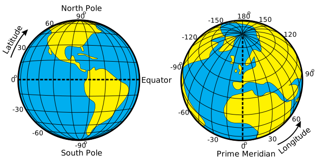
The "latitude" of a point on Earth's surface is the angle between the equatorial plane and the straight line that passes through that point and through (or close to) the center of the Earth. Lines joining points of the same latitude trace circles on the surface of Earth called parallels, as they are parallel to the equator and to each other. The north pole is 90° N; the south pole is 90° S. The 0° parallel of latitude is designated the equator, the fundamental plane of all geographic coordinate systems. The equator divides the globe into Northern and Southern Hemispheres. Line across the Earth 0° Prime Meridian.
The "longitude" of a point on Earth's surface is the angle east or west of a reference meridian to another meridian that passes through that point. All meridians are halves of great ellipses (often called great circles), which converge at the north and south poles. The meridian of the British Royal Observatory in Greenwich, in south-east London, England, is the international prime meridian, although some organizations (such as the French Institut Géographique National) continue to use other meridians for internal purposes. The prime meridian determines the proper Eastern and Western Hemispheres, although maps often divide these hemispheres further west in order to keep the Old World on a single side. The antipodal meridian of Greenwich is both 180°W and 180°E. This is not to be conflated with the International Date Line, which diverges from it in several places for political reasons, including between far eastern Russia and the far western Aleutian Islands.
Source: Wikipedia
BeMap server uses the WGS84 format to define the coordinates. The range allowed by the WGS84 is -180 to +180 for the longitude and -90 to +90 for the latitude.
Coordinate parameters are defined as follow: longitude,latitude. Example: 2.29494,48.85853.