REST API, Service version 1.0.0
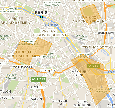
# Geo-fencing service A geo-fence is a virtual perimeter for a real-world geographic area. A geo-fence could be dynamically generated-as in a radius around a point location, or a geo-fence can be a predefined set of boundaries (such as school zones or neighborhood boundaries). _For more details: [Wikipedia](https://en.wikipedia.org/wiki/Geo-fence)_ ## Summary 1. Request 1. Mandatory parameters 2. Optional parameters 2. Response 1. Details of fields 2. Response samples ## Request The request must be sent with the HTTP method `POST` and the HTTP header `Content-Type` set to `application/json`. Sample: URI: `/bgis/service/geofencing/1.0` POST data: ```javascript { "fenceShapes": [ { "id": "1", "type": "CIRCLE", "center": { "lon": 7.42806, "lat": 43.75272 }, "radius": 3000 } ], "positionType": "POLYGON", "positions": [ { "lon": 7.41888, "lat": 43.73252 }, { "lon": 7.41806, "lat": 43.73272 }, { "lon": 7.41537, "lat": 43.73169 }, { "lon": 7.41516, "lat": 43.73184 }, { "lon": 7.41461, "lat": 43.73224 } ] } ``` All coordinates are defined by longitude and latitude, see the [coordinate system](https://benomad.com/dev/doc/bemap-api/guides/reference/glossary-coordinate-system.md) glossary for more details. ### __Parameters__ - `fenceShapes` (GeoFenceShp[], required): Define a fence shape to perform a intersection test between the route and fence. - `center` (Coordinate, required): Center of circle fence. - `lon` (number (double), required): Longitude in degrees decimal ([WGS84](https://benomad.com/dev/doc/bemap-api/guides/reference/glossary-coordinate-system.md)). Also accepted as `longitude`. - `lat` (number (double), required): Latitude in degrees decimal ([WGS84](https://benomad.com/dev/doc/bemap-api/guides/reference/glossary-coordinate-system.md)). Also accepted as `latitude`. - `radius` (integer (int64), required): Radius of circle fence. - `vertices` (Coordinate[], required): Vertices of polygon fence. - `lon` (number (double), required): Longitude in degrees decimal ([WGS84](https://benomad.com/dev/doc/bemap-api/guides/reference/glossary-coordinate-system.md)). Also accepted as `longitude`. - `lat` (number (double), required): Latitude in degrees decimal ([WGS84](https://benomad.com/dev/doc/bemap-api/guides/reference/glossary-coordinate-system.md)). Also accepted as `latitude`. - `id` (integer (int64)): The fence id. If value is negative the server will set it with an auto-incrementing number. - `type` (enum): Define the type of geometric shape of fence, like CIRCLE or POLYGON. - `CIRCLE`: Circle. - `POLYGON`: Polygon. - `positions` (GeofencingPos[], required): The coordinates will be compared with the fences. - `lon` (number (double), required): Longitude in degrees decimal ([WGS84](https://benomad.com/dev/doc/bemap-api/guides/reference/glossary-coordinate-system.md)). Also accepted as `longitude`. - `lat` (number (double), required): Latitude in degrees decimal ([WGS84](https://benomad.com/dev/doc/bemap-api/guides/reference/glossary-coordinate-system.md)). Also accepted as `latitude`. - `radius` (integer (int64)): Radius in meters. - `geoserver` (string): Geoserver name. - `swidx` (integer (int32), deprecated): Switch index. - `positionType` (enum): Define type of `positions` parameter used to perform a comparison between fence shapes and coordinates. - `CIRCLE`: Define type of xy parameter as circle to perform a comparison between fence shapes and a circle. - `POLYLINE`: Define the interpretation of coordinates of xy parameter to perform a comparison between fence shapes and a polyline. - `POLYGON`: Define the interpretation of coordinates of xy parameter to perform a comparison between fence shapes and a polygon. - `options` (enum[]): Comma-separated list of one or more geo-fencing options. - `SEARCH`: Enable to search the fences with coordinate, in this case the parameter `positions` can be use the radius. ## Response Return a list in same order of xy parameters (list of coordinates) with state INSIDE, OUTSIDE or INTERSECT. ### Result of compare test * positionStates: The status of result. Available values below. | Values | Illustration | Description | |:----------:|:------------:|-------------| | `INSIDE` | | Defines if the tested coordinate is in fence. |
| `OUTSIDE` |
| Defines if the tested coordinate is in fence. |
| `OUTSIDE` |  | Defines if the tested coordinate is out of fence. |
| `INTERSECT` |
| Defines if the tested coordinate is out of fence. |
| `INTERSECT` |  | Position is not completely inside or outside but the shapes are intersected. |
### Details of fields
- `fenceResults` (GeofencingRes[]): Return a list in same order of xy parameters (list of coordinates) with state INSIDE, OUTSIDE or INTERSECT.
- `id` (integer (int64)): Unique ID of fence.
- `type` (enum): Type of geometry.
- `CIRCLE`: Circle.
- `POLYGON`: Polygon.
- `fenceShape` (GeoFenceShp): Shape of fence used to perform the test.
- `center` (Coordinate, required): Center of circle fence.
- `lon` (number (double), required): Longitude in degrees decimal ([WGS84](https://benomad.com/dev/doc/bemap-api/guides/reference/glossary-coordinate-system.md)). Also accepted as `longitude`.
- `lat` (number (double), required): Latitude in degrees decimal ([WGS84](https://benomad.com/dev/doc/bemap-api/guides/reference/glossary-coordinate-system.md)). Also accepted as `latitude`.
- `radius` (integer (int64), required): Radius of circle fence.
- `vertices` (Coordinate[], required): Vertices of polygon fence.
- `lon` (number (double), required): Longitude in degrees decimal ([WGS84](https://benomad.com/dev/doc/bemap-api/guides/reference/glossary-coordinate-system.md)). Also accepted as `longitude`.
- `lat` (number (double), required): Latitude in degrees decimal ([WGS84](https://benomad.com/dev/doc/bemap-api/guides/reference/glossary-coordinate-system.md)). Also accepted as `latitude`.
- `id` (integer (int64)): The fence id. If value is negative the server will set it with an auto-incrementing number.
- `type` (enum): Define the type of geometric shape of fence, like CIRCLE or POLYGON.
- `CIRCLE`: Circle.
- `POLYGON`: Polygon.
- `positionStates` (enum[]): Defines position state of tested coordinate on the fence geometry.
- `INWARD`: Defines if the tested coordinate is an inward intersection.
- `INSIDE`: Defines if the tested coordinate is in fence.
- `OUTWARD`: Defines if the tested coordinate is an outward intersection.
- `OUTSIDE`: Defines if the tested coordinate is out of fence.
- `INTERSECT`: Position is not completely inside or outside but the shapes are intersected.
### Response samples
JSON Sample:
```javascript
{
"fenceResults": [
{
"id": 1,
"type": "CIRCLE",
"positionStates": [
"OUTSIDE"
]
}
]
}
```
| Position is not completely inside or outside but the shapes are intersected. |
### Details of fields
- `fenceResults` (GeofencingRes[]): Return a list in same order of xy parameters (list of coordinates) with state INSIDE, OUTSIDE or INTERSECT.
- `id` (integer (int64)): Unique ID of fence.
- `type` (enum): Type of geometry.
- `CIRCLE`: Circle.
- `POLYGON`: Polygon.
- `fenceShape` (GeoFenceShp): Shape of fence used to perform the test.
- `center` (Coordinate, required): Center of circle fence.
- `lon` (number (double), required): Longitude in degrees decimal ([WGS84](https://benomad.com/dev/doc/bemap-api/guides/reference/glossary-coordinate-system.md)). Also accepted as `longitude`.
- `lat` (number (double), required): Latitude in degrees decimal ([WGS84](https://benomad.com/dev/doc/bemap-api/guides/reference/glossary-coordinate-system.md)). Also accepted as `latitude`.
- `radius` (integer (int64), required): Radius of circle fence.
- `vertices` (Coordinate[], required): Vertices of polygon fence.
- `lon` (number (double), required): Longitude in degrees decimal ([WGS84](https://benomad.com/dev/doc/bemap-api/guides/reference/glossary-coordinate-system.md)). Also accepted as `longitude`.
- `lat` (number (double), required): Latitude in degrees decimal ([WGS84](https://benomad.com/dev/doc/bemap-api/guides/reference/glossary-coordinate-system.md)). Also accepted as `latitude`.
- `id` (integer (int64)): The fence id. If value is negative the server will set it with an auto-incrementing number.
- `type` (enum): Define the type of geometric shape of fence, like CIRCLE or POLYGON.
- `CIRCLE`: Circle.
- `POLYGON`: Polygon.
- `positionStates` (enum[]): Defines position state of tested coordinate on the fence geometry.
- `INWARD`: Defines if the tested coordinate is an inward intersection.
- `INSIDE`: Defines if the tested coordinate is in fence.
- `OUTWARD`: Defines if the tested coordinate is an outward intersection.
- `OUTSIDE`: Defines if the tested coordinate is out of fence.
- `INTERSECT`: Position is not completely inside or outside but the shapes are intersected.
### Response samples
JSON Sample:
```javascript
{
"fenceResults": [
{
"id": 1,
"type": "CIRCLE",
"positionStates": [
"OUTSIDE"
]
}
]
}
```